Preliminary design

Preliminary design


Preliminary Design Executive Direction operational electrical and special systems


Overall coordination, collaboration in architectural design final and enforceable.
Preliminary and final design electrical systems coordinating fire prevention safety.
Works management


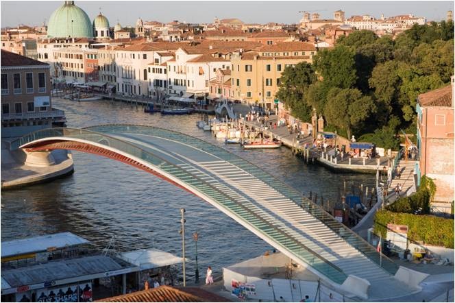
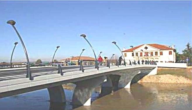
New steel Bridge with one central bay for the connection between the riversides of Canal Grande in Venice.
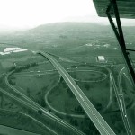
The project interested about 9.5 km of major road (10.5 m width), from the current primary route S.S.128 with a roundabout built South of the town of Senorbì, up to the link on the current S.S. 128, via roundabout, South of the intersection with Gesico Provincial Road. In addition to the two roundabout intervention on the beginning and on the end of the intervention, there are three other roundabout intersections.
Along the roadway the major structures consist of two bridges: a 175 m long bridge from the progressive 4+753.82 to 4+927.42; and the other bridge with a development of 105 m from the progressive 7+792.42 to 7+896.02; the minor structures are: 13 concrete culverts, 2 road underpasses and 12 concrete tubular for water drainage from road platform. The project entails also about 6.9 km of secondary roads, (4 m width), to ensure the inter-estate traffic
The project interested the link between the motorway toll gate at Piovene Rocchette (A31 highway) and the truck road SS350 at Schiri, in the municipal area of Velo d’Astico (VI).
The total length of this link is 7,8 km.
The main structures that should be also realized in the first track between the A4 and the A27 highways are the following:
• 3 by-passes
• 4 overpass
• 3 viaducts (total length of approx. 1km)
The total value of t works was approx: 95.900.000 euro
The services provid were the following:
• Environmental Impact Assessment
• Final design: hydraulic design, Structural Design (viaducts, galleries, underpasses, retaining walls,etc) Drainage Design, Pavement Design, Final Design Report, Design of environmental mitigation works

This infrastructure project preparation concerns the regional competitiveness of the Vicenza, Padua and Rovigo provinces.
The Southward completion involves an interconnection with A4 Motorway to that with the S.S.n. 434 ” Transpolesana” (State Road), of about 52.8km.
The road alignment starts from the junction on the A4 Motorway (Milan-Venice), continuing on from the northern part of the same A31 Motorway (with the interchanges of Piovene Rocchette and Thiene). The centreline therefore has a north- south orientation and runs parallel to the layout of the S.S. n. 247 “Riviera Berica” as far as Noventa Vicentina. It then continues up to the tollgate of S. Margherita d’Adige – Megliadino S. Vitale extending south in direction of the S.S. n. 499, after having crossed the River Adige.
Among the major works, the project foresees the realization of an important bridge to cross the River Adige, between the towns of Piacenza d’Adige and Badia Polesine, and of some viaducts, for an overall length of approximately 4km, corresponding to about 95,000 sqm. of bridge decks.
The project envisages the realization of the following main viaducts, proceeding from North toward South: Torri di QUARTESOLO, 577.5m; River BACCHIGLIONE, 627m; River FRASSINE, 693m; SALETTO, 744m; River VAMPADORE, 165m; River FRATTA, 198m; River ADIGE, 992m.
Three tunnels are foreseen in the preliminary design, of which the first one, called Albettone Tunnel, is of traditional type and underpasses the Castellaro Mountain, while the other two, called Agugliaro and Saline tunnels, are of the “cut & cover” type.
The project concerns the demolition of the existing steel and concrete bridge with three longitudinal bays and the following rebuilding of the structure.
Projects Description
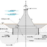
Palik is a zoned embankment dam with impervious core.
Its typical section presents different zones, from upstream to downstream: an upstream shell (rockfill), a transition zone (sandy-gravelly material), a core (clayey material), two filters (sandy and gravelly materials) and a downstream shell (same as upstream shell).
For surface foundation preparation a stripping of 1-1.5 m is foreseen. The core was deepened up to the top of the bedrock, that lies 6-10 m below the ground level; this solution was considered the most effective and simple to get the tightness of the foundation. As for typology, a homogeneous cofferdam was preferred; excluding an impervious homogeneous embankment (no suitable natural material is available), a rockfill embankment with an upstream impervious device was chosen.
• Type of the dam:
Embankment, with some concrete elements for ancillary works on left side. Length of the embankment: 918 m
Length of concrete dam: 170 m
Total length: 1063 m
• Height of the dam: 54.5 m from river bottom
• Dam crest elevation: 361.5 m a.s.l.
• NWL: 350.0 m a.s.l.
• Max WL: ~ 356.3 m a.s.l. for flood of 1000 years RP
• Exceptional Max WL: ~ 359.6 m a.s.l. for flood of 10000 years RP and 2 blocked gates
• Min WL: ~ 335.5 m a.s.l.
• Reservoir capacity: 330 x 106 m3 at NWL, 520 x 106 at MWL
• Dead storage: 67.5 x 10⁶ m3 at 333.0 m a.s.l.
• Reservoir area: 30 km2 at MWL
• Catchment area: 18500 km2
• Spillway; structure located on right side and consisting in two free sills and a gated sill – design flow: 16357 m3/s (1000 years RP).